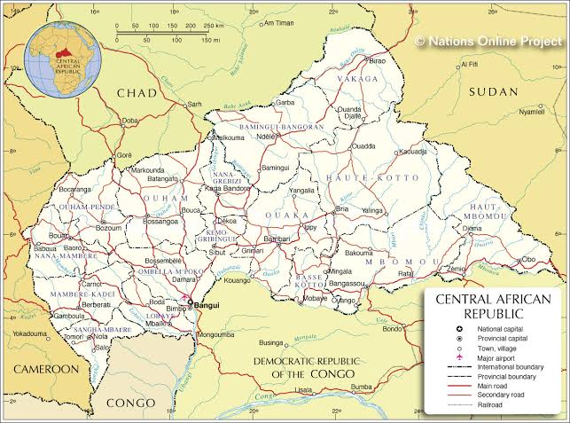
Detail Map Of Central African Republic:
On Central African Republic map, it is a landlocked country in Central Africa. The biggest city Bangui is the capital of the Central African Republic. The total area of the Central African Republic is 622,984 square kilometers. The population is 4.659 million. The official languages of Central African Republic are French and Sangho. In most Central African families, women continue to play a key role in the collection, production, preservation, distribution and preparation of food. Hunting, catching and fishing (male occupations) are still important to many Central Africans, with women fishing in some areas during the dry season. The production of commercial crops such as coffee, cotton and tobacco is usually predominantly male, but women are the main food producers of household consumption. The staple foods include cassava, rice, squash, pumpkin and plantains, which are usually served with spices and grilled meats.
Central African Republic Map
In essence, the Central African Republic is an up and down of the plateau. The central and southern parts are a series of gentle forest hills, 2,000 feet above sea level. The southeast is a dense tropical rainforest on the upper Ubangi River and the north is a desert-free savannah. On the western border with Cameroon, the land was lifted into the high granite plateau of the Carre Mountains. The Bongos block in the northeast extends to the Sudan. The tributaries of the chairs (sari) and the river Longong are traversed throughout the central and northern parts, while the Ubangi river system dominates the south, as it forms the southern border of the country and the Congo (Kinshasa). The highest point in the Central African Republic is the mountain. Kayagangiri is located at 1,660 m (4,660 ft.), the lowest point in the country is the Oban River, which is 1,039 ft. (335 m) long.